buried in the comments for the previous post with a similar title, i said:

that shows the "combined statistical areas" (CSAs) in ... aqua? teal? shades, and the metropolitan statistical areas outside of CSAs in tan. (really big map for those who want to look at specific areas in detail.)

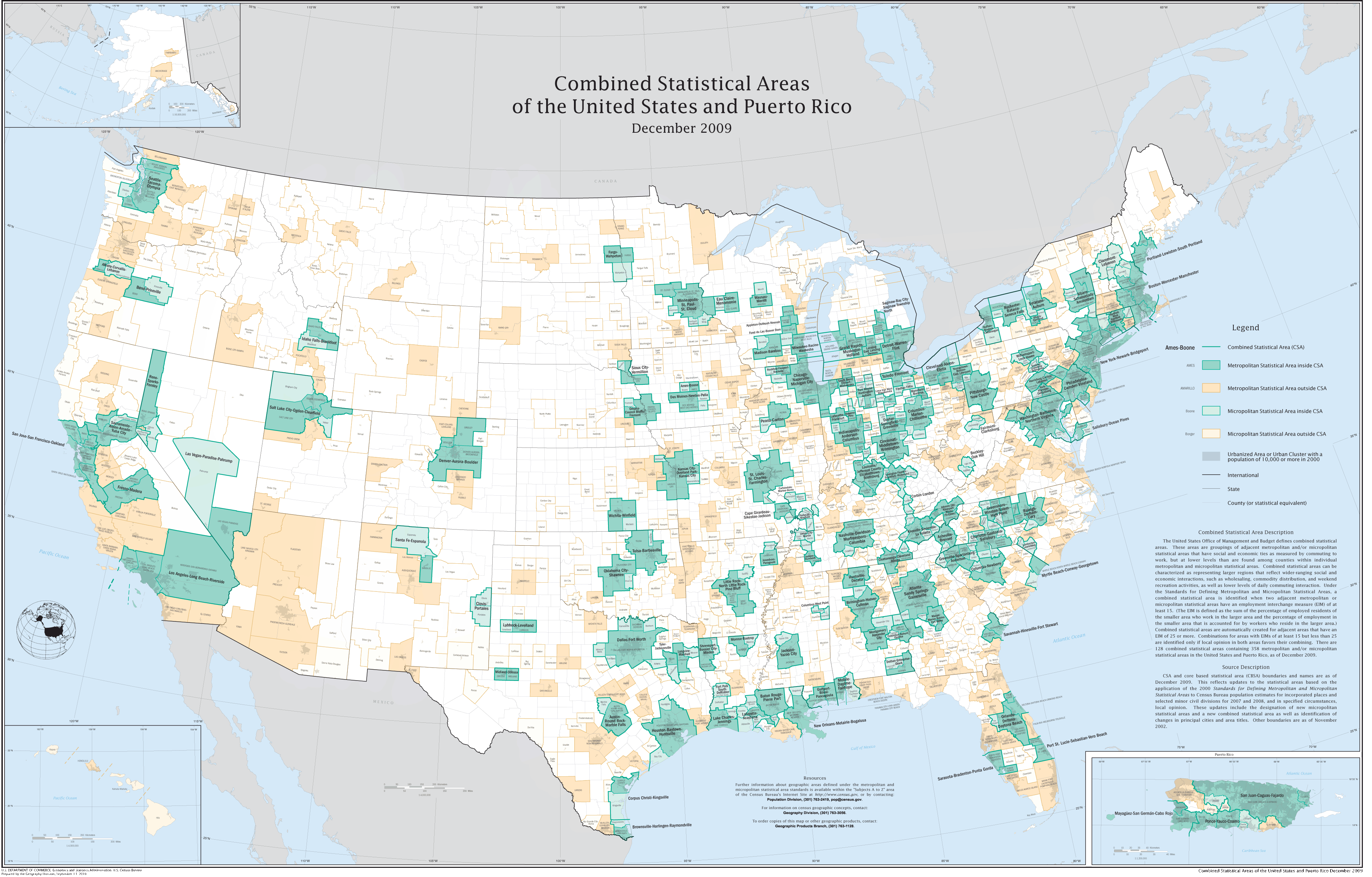
other than the boundaries for the chicago sprawl extending a bit far into farmland (because of the county-line requirement), that's the area i consider to be metro chicago. i might even be willing to throw in milwaukee, too.

likewise for the philly sprawl, which clearly lumps us (wilmington and its suburbs) in with philly, despite the pretensions of wilmington's leaders. (wilmington once was its own economic core, but that hasn't been true since the automobile made commuting to philly relatively convenient.)
the grey-shaded areas are pretty much what i really think should be the proper loci of modern american policy-making, but since the census flattened out the layers of the maps, pulling them out was too hard. (and while i have a simple GIS program, i couldn't find the data for the grey areas.) the grey-shaded areas aren't just "urban" - they go pretty far out into the suburbs. the southwestern end of the grey philly sprawl appears to be elkton, maryland, as i think it should be. (also note the large gap between it and the washing-more sprawl. i'm simply amazed that the susquehanna valley's interruption of the fall line continues to influence settlement even though water power hasn't been economically significant in the region since the civil war.)
that still leaves large rural areas outside the cities. i really do want to keep them separate, because the difference in population between megalopolitan sprawls and rural areas already strains the limits of bicameral legislatures within existing states. with the political reorganization i think i want, rural voters would be hopelessly outnumbered if lumped in with the sprawls. (or the sprawls would be needlessly hamstrung dealing with yokels in their senate.) i guess the rural areas end up giving the rump states reasons to exist. god only knows what sort of mess that would make in the federal senate.
i need to dig up and push the numbers, but i think this system would end up with > 75% of the us population in roughly 200 metro areas with the powers of (at least) today's states¹, replacing the outmoded state-county-city mess we have with something that better represents today's voters and their needs/wants.
1: i also want to better recognize leagues of metro areas than the constitution's vague references to enforcing treaties between the states. i'm not convinced the us needs a unitary environmental policy -- and in fact it doesn't have one, since california is a special case -- but the washington-boston megalopolitan axis could certainly use one, and it would be good if it could act as a unit without interference from other similar large areas and/or inability to set and enforce such policies among its member megalopoli.
I'm not sure cities per se are the right locale for experimentation. My thinking these days about the proper scale of governance is mostly centered on metropolian areas.the way the census defines metropolitan and the amusingly named "micropolitan" ares is pretty much what i want, although i think the micropoli are frankly too small to be useful policy-making areas. i also wouldn't include existing county lines as significant in the definition, but it's at least a starting point. since the us census has already made some detailed maps of metro areas, i've lightly hacked them up to give an idea of what i'm thinking of:
that shows the "combined statistical areas" (CSAs) in ... aqua? teal? shades, and the metropolitan statistical areas outside of CSAs in tan. (really big map for those who want to look at specific areas in detail.)
other than the boundaries for the chicago sprawl extending a bit far into farmland (because of the county-line requirement), that's the area i consider to be metro chicago. i might even be willing to throw in milwaukee, too.
likewise for the philly sprawl, which clearly lumps us (wilmington and its suburbs) in with philly, despite the pretensions of wilmington's leaders. (wilmington once was its own economic core, but that hasn't been true since the automobile made commuting to philly relatively convenient.)
the grey-shaded areas are pretty much what i really think should be the proper loci of modern american policy-making, but since the census flattened out the layers of the maps, pulling them out was too hard. (and while i have a simple GIS program, i couldn't find the data for the grey areas.) the grey-shaded areas aren't just "urban" - they go pretty far out into the suburbs. the southwestern end of the grey philly sprawl appears to be elkton, maryland, as i think it should be. (also note the large gap between it and the washing-more sprawl. i'm simply amazed that the susquehanna valley's interruption of the fall line continues to influence settlement even though water power hasn't been economically significant in the region since the civil war.)
that still leaves large rural areas outside the cities. i really do want to keep them separate, because the difference in population between megalopolitan sprawls and rural areas already strains the limits of bicameral legislatures within existing states. with the political reorganization i think i want, rural voters would be hopelessly outnumbered if lumped in with the sprawls. (or the sprawls would be needlessly hamstrung dealing with yokels in their senate.) i guess the rural areas end up giving the rump states reasons to exist. god only knows what sort of mess that would make in the federal senate.
i need to dig up and push the numbers, but i think this system would end up with > 75% of the us population in roughly 200 metro areas with the powers of (at least) today's states¹, replacing the outmoded state-county-city mess we have with something that better represents today's voters and their needs/wants.
1: i also want to better recognize leagues of metro areas than the constitution's vague references to enforcing treaties between the states. i'm not convinced the us needs a unitary environmental policy -- and in fact it doesn't have one, since california is a special case -- but the washington-boston megalopolitan axis could certainly use one, and it would be good if it could act as a unit without interference from other similar large areas and/or inability to set and enforce such policies among its member megalopoli.