![[personal profile]](https://www.dreamwidth.org/img/silk/identity/user.png)
shenandoah: most of the adventures
Aug. 9th, 2026 08:21 pmsince we were starting at the southern end of the park, we'd thought we'd try a hike almost as far south as one can get: turk mountain, which the park service breezily describes as "easiest". um, not really, and that unhelpful advice led the mountain to defeat us.
in short, maximum slope matters. the park service's rating system is simply a function of horizontal distance and elevation gain. it's not a bad zeroth-order approximation – longer hikes with greater elevation change are generally harder than short ones that are nearly flat – but ultimately wrong. don't believe me? consider the difference between scaling a 100 foot tall cliff and taking the stairs in a 100 foot tall building. the latter has a greater horizontal distance, and so oddly rates more as difficult. it's a a strange edge case, but one that bit us us firmly on the ass.
so, having been assured that the hike was "easiest", we didn't pace ourselves. overall, the grade should be nearly flat: gaining 700 feet in a little over two miles is about a 6% grade. yeah, we can take that at close to a walking pace.
but as the picture on the park's web site makes clear, that's not how it works. there's a slight descent along a ridge to turk mountain, and then a climb. and the climb is pretty steep in places. as far as i can tell from a topo map and an elevation profile of the hike – both of which i looked at afterwards – there's a section where we gained about 200 feet in something between 400 and 600 feet of horizontal distance. a 1:2 slope is a shallow staircase, and 1:3 is a moderately steep climb. but we took them too fast, and wore ourselves out.¹
all the way, i was cursing myself for being woefully out of shape, since we'd climbed 400 feet up switchbacks getting onto the shira plateau on kilimanjaro just four years earlier... while sick as dogs. but we did that very, very slowly.
so, when we got to what seemed like the top – a rocky place with a view, where other people were sitting and talking – we stopped there. but when were were leaving, i saw a boulder with a blaze indicating that the trail turned right. where we'd turned left to go admire the view is essentially a landing for the trail nearly doubling back on itself to climb higher. we said to hell with it and started back down. that we missed such an obvious blaze is an indication of how tired we were.
1: we went out and back in 1:42, according to dïe überblønde's timer, including flopping around at the overlook. the park service estimates 2:15 for the hike, and the guide we should have looked at says 2-4 hours.
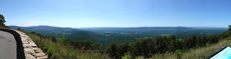
the trip improved almost immediately thereafter. i pulled over at the simmons gap overlook, which has a view we'd never seen before.

( more places, more pictures )
soon: compton peak, the other mountain that defeated us.
in short, maximum slope matters. the park service's rating system is simply a function of horizontal distance and elevation gain. it's not a bad zeroth-order approximation – longer hikes with greater elevation change are generally harder than short ones that are nearly flat – but ultimately wrong. don't believe me? consider the difference between scaling a 100 foot tall cliff and taking the stairs in a 100 foot tall building. the latter has a greater horizontal distance, and so oddly rates more as difficult. it's a a strange edge case, but one that bit us us firmly on the ass.
so, having been assured that the hike was "easiest", we didn't pace ourselves. overall, the grade should be nearly flat: gaining 700 feet in a little over two miles is about a 6% grade. yeah, we can take that at close to a walking pace.
but as the picture on the park's web site makes clear, that's not how it works. there's a slight descent along a ridge to turk mountain, and then a climb. and the climb is pretty steep in places. as far as i can tell from a topo map and an elevation profile of the hike – both of which i looked at afterwards – there's a section where we gained about 200 feet in something between 400 and 600 feet of horizontal distance. a 1:2 slope is a shallow staircase, and 1:3 is a moderately steep climb. but we took them too fast, and wore ourselves out.¹
all the way, i was cursing myself for being woefully out of shape, since we'd climbed 400 feet up switchbacks getting onto the shira plateau on kilimanjaro just four years earlier... while sick as dogs. but we did that very, very slowly.
so, when we got to what seemed like the top – a rocky place with a view, where other people were sitting and talking – we stopped there. but when were were leaving, i saw a boulder with a blaze indicating that the trail turned right. where we'd turned left to go admire the view is essentially a landing for the trail nearly doubling back on itself to climb higher. we said to hell with it and started back down. that we missed such an obvious blaze is an indication of how tired we were.
1: we went out and back in 1:42, according to dïe überblønde's timer, including flopping around at the overlook. the park service estimates 2:15 for the hike, and the guide we should have looked at says 2-4 hours.
the trip improved almost immediately thereafter. i pulled over at the simmons gap overlook, which has a view we'd never seen before.
( more places, more pictures )
soon: compton peak, the other mountain that defeated us.